
We
build
digital
world out of data.
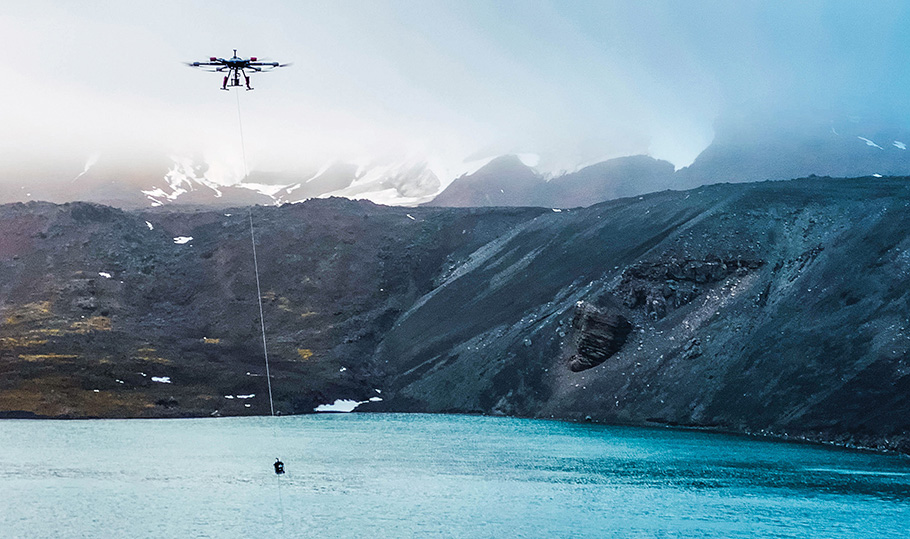
Welcome to the forefront of technological innovation and exploration. At DDV, we specialize in harnessing the power of cutting-edge drone technology to drive advancements in various industries. As a leading provider of drone-based scientific solutions, we are dedicated to revolutionizing research, analysis, and exploration.
We collaborate with smart and creative people to achieve outstanding.

Our Commitment to Excellence
At DDV, we believe in the limitless possibilities that arise when technology and science converge. With a passion for discovery and a commitment to excellence, we offer tailored drone-based mapping solutions that cater to the unique needs of scientific research, environmental monitoring, geological exploration, agricultural analysis, and beyond.
WHY CHOOSE US?
We solve creative delusions efficiently
Innovative Drone Technology: Our state-of-the-art drones are equipped with advanced sensors and imaging devices, offering unparalleled accuracy and efficiency in data collection.
Expertise Across Industries: With a team of skilled professionals, including drone pilots, scientists, engineers, and data analysts, we possess the expertise to address diverse scientific challenges.
Customized Solutions: We understand that every industry is unique. That’s why we collaborate closely with our clients to develop customized drone-based solutions tailored to their research goals and objectives.
Data-driven Insights: Beyond capturing raw data, we excel at transforming information into actionable insights. Our data analysis techniques provide meaningful interpretations, empowering scientists and researchers to make informed decisions.
Commitment to Sustainability: Our approach is environmentally conscious, employing eco-friendly practices and minimizing our ecological footprint. Our drone technology enables non-intrusive data collection, ensuring minimal disruption to natural habitats.
15
Projects Completed
10
Happy Clients
300
Hours Spent
3
Members
Our Range of Services / Industries
GEOLOGICAL EXPLORATION & MINING
Explore geological formations, identify mineral deposits, and assess geological hazards using geophysical sensors and mapping technologies.
- Geological Surveying: Accurate analysis of geological formations for optimal drilling and mining operations.
- understanding the volume of excavated materials allows for rigorous environmental impact assessments. We help mining projects evaluate their ecological footprint and implement sustainable practices, fostering responsible mining initiatives.
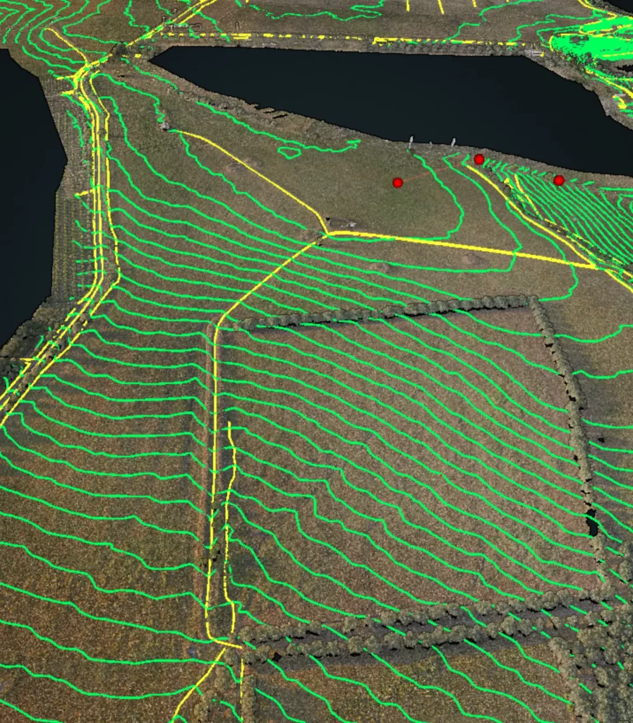
PRECISION AGRICULTURE
Multispectral analysis – Wildlife watch – Cropland damage
Optimize agricultural practices by analyzing crop health, soil quality, and irrigation needs, leading to increased yields and sustainable farming methods.
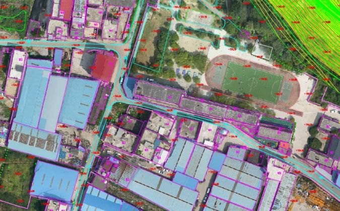
MAPPING
Conduct groundbreaking research with our high-resolution aerial imagery and sensor data, enabling in-depth analysis and hypothesis testing.
- GIS Mapping: Capture and visualize geographic data to inform strategic decision-making.
- Facility and Pipeline Mapping: Detailed 3D modelling for efficient facility planning and pipeline routing.
ENVIRONMENTAL MONITORING
Monitor environmental changes, track biodiversity, and assess the impact of climate change through comprehensive aerial surveys and data analysis.

INFRASTRUCTURE INSPECTION
Safeguard critical infrastructure by conducting detailed aerial inspections, detecting vulnerabilities, and ensuring the integrity of structures and facilities, enhancing your situational awareness for effective maintenance and infrastructure management.
- Thermal Imaging: Monitor equipment health and detect anomalies for preventive maintenance.
- LiDAR Scanning: High-resolution laser scanning for detailed terrain modelling and spatial analysis.
Mining Solution
Volumetric Analysis for Mining Projects:
Unlocking the Potential Beneath the Surface In the dynamic realm of mining projects, understanding the volume and composition of mineral deposits is paramount. Volumetric analysis, a sophisticated technique central to modern mining operations, provides invaluable insights into mineral resources’ spatial distribution, size, and quality. At DDV, we specialize in advanced volumetric analysis, empowering mining enterprises to make informed decisions, optimize resource extraction, and ensure the sustainable utilization of precious resources.
Why Volumetric Analysis Matters:
Mining projects operate on a foundation of accurate data. Volumetric analysis, utilizing state-of-the-art technologies such as LiDAR (Light Detection and Ranging), drone-based surveys, and 3D modeling, enables precise measurement of ore bodies, waste materials, and geological structures. This detailed understanding of volume is fundamental for mine planning, resource estimation, and financial forecasting. By embracing volumetric analysis, mining companies can enhance operational efficiency, minimize waste, and maximize the economic potential of their projects.
– Volumetric Analysis Solutions
At DDV, we offer comprehensive volumetric analysis services tailored to the unique requirements of each mining project:
Accurate Resource Estimation: Utilizing advanced geospatial data, 3D modelling and GIS mapping, we provide accurate estimates of mineral resources, enabling mining companies to assess the economic viability of extraction and plan mining activities effectively.
Waste Management: Volumetric analysis aids in identifying and quantifying waste materials within mining sites. By optimizing waste management strategies, mining projects can minimize environmental impact and reduce operational costs.
Pit Design and Optimization: Precise volumetric calculations inform optimal pit designs, ensuring maximum resource recovery while adhering to safety regulations and environmental standards. Our analysis guides efficient excavation and ore extraction practices.
Environmental Impact Assessment: Understanding the volume of excavated materials allows for rigorous environmental impact assessments. We help mining projects evaluate their ecological footprint and implement sustainable practices, fostering responsible mining initiatives.
Real-time Monitoring: Through drone-based surveys and LiDAR technology, we provide real-time volumetric monitoring of mining sites. This continuous assessment aids in proactive decision-making, allowing for adaptive strategies based on changing site conditions.
Spatial Analysis for Natural Resources
Navigating the Path to Sustainable Exploration
In the intricate tapestry of our natural world, understanding spatial relationships is the key to unlocking its abundant resources responsibly and sustainably. At DDV, we specialize in cutting-edge spatial analysis techniques that empower industries, researchers, and environmentalists to delve into the heart of natural resources. Our commitment lies in harnessing the power of spatial analysis to inform informed decision-making, preserve ecological balance, and pave the way for a harmonious coexistence between humanity and nature.
The Significance of Spatial Analysis:
Spatial analysis goes beyond traditional data analysis methods, focusing on the geographic context of data points. By scrutinizing the spatial distribution, patterns, and relationships within natural landscapes, we gain profound insights into resource availability, environmental impact, and biodiversity. This understanding forms the cornerstone of sustainable resource management, environmental conservation, and strategic planning for a multitude of industries.
– Spatial Analysis Solutions for Natural Resources
At DDV, we offer a diverse array of spatial analysis solutions tailored to the unique challenges posed by natural resource exploration and conservation:
Resource Mapping: Utilizing Geographic Information Systems (GIS) and remote sensing technologies, we create detailed resource maps highlighting the presence and distribution of minerals, water bodies, forests, and other valuable resources. Our maps facilitate precise exploration and efficient utilization of natural assets.
Environmental Impact Assessment: We conduct in-depth spatial analysis to assess the potential impact of human activities on natural ecosystems. By modelling and visualizing environmental changes, we guide responsible land use planning, ensuring the preservation of delicate habitats and biodiversity.
Precision Agriculture: Spatial analysis aids farmers in optimizing agricultural practices. By analyzing soil quality, water availability, and crop health in a spatial context, we enable precision agriculture techniques, reducing resource wastage and enhancing crop yields sustainably.
Wildlife Conservation: Our spatial analysis solutions help conservationists identify critical habitats, migration routes, and ecological corridors essential for wildlife survival. By understanding spatial patterns, we contribute to the conservation of endangered species and the preservation of natural biodiversity.
Infrastructure Planning: We conduct spatial analysis to identify suitable sites for industries requiring land for infrastructure development, considering environmental constraints and resource availability. Our analysis guides sustainable development projects that minimize environmental impact.
Forestry and vegetation mapping: By utilizing state-of-the-art technologies such as satellite imaging, drones, and GIS mapping, we conduct precise evaluations of forests. These tools allow us to make well-informed decisions, monitor forest health, and plan sustainable interventions more efficiently. Conserving biodiversity is crucial for maintaining healthy forests. We take an out-of-the-box approach to provide solutions to protect endangered species, preserve habitats, and promote biodiversity, thereby safeguarding the intricate web of life within our forests.
